======================================================================
지구는_과연_평평한가_김정민박사
https://www.youtube.com/watch?v=r9YLbrU0wFY
======================================================================
Stars rotate around north star in counter clockwise
when you see north star
We can say that, when you see rotating stars around north star in counter clockwise,
it means you're seeing north sky location from south sky location
Once you turn 180 degree and see stars,
stars will look rotating in clockwise
Above phenomenon happens due to earth's rotation.
======================================================================
In southern continent, you can't see north star
In southern continent, however, there is south star which plays similar role with north star.
======================================================================
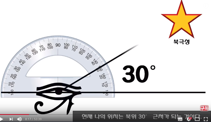
When you see north star on flat ground,
if the angle between flat ground and north star is 30 degree,
that means location you're standing on is almost 30 degree of north latitude
(North latitude is higer latitudes than equator(0 latitude))
 ======================================================================
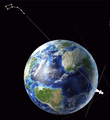
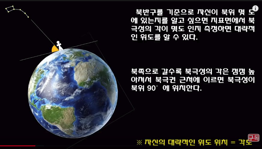 Above illustration depicts when you see north star in far northern area,
north star is located in higher location
======================================================================
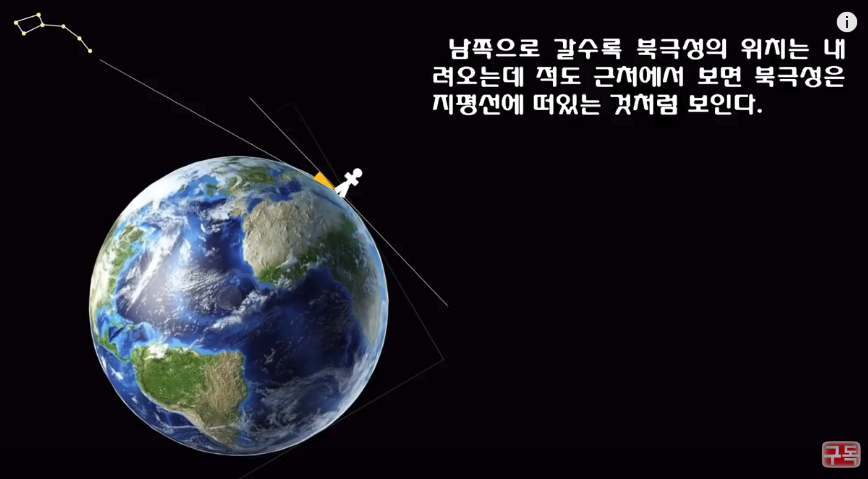
If you go down towards far south,
north star looks being lower even up to almost ground altitude as illustration.
Above illustration depicts when you see north star in far northern area,
north star is located in higher location
======================================================================
If you go down towards far south,
north star looks being lower even up to almost ground altitude as illustration.
 ======================================================================
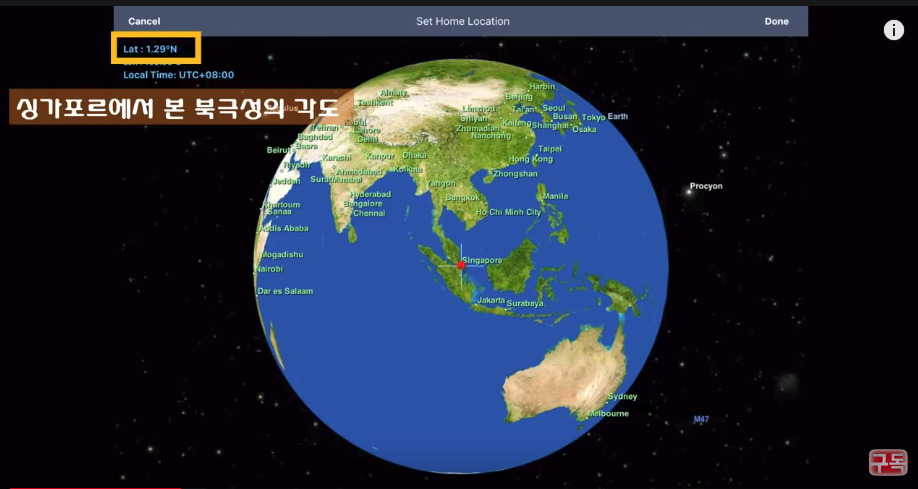
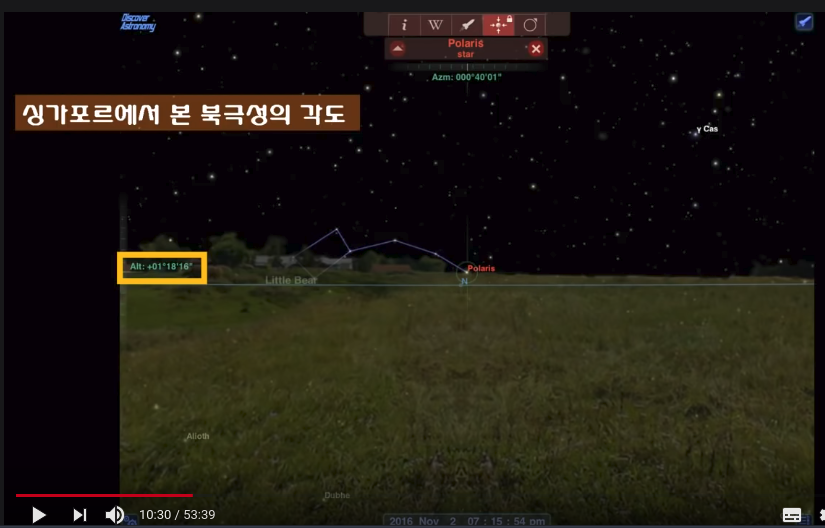
Seoul is located in 37.5 degree of north latitude.
Singapore is located in 1.29 degree of north latitude.
1.29 in yellow box (top left) represents angle between flat ground and north star,
when you see north star in Singapore.
======================================================================
Seoul is located in 37.5 degree of north latitude.
Singapore is located in 1.29 degree of north latitude.
1.29 in yellow box (top left) represents angle between flat ground and north star,
when you see north star in Singapore.
 Altitude of north star when you see it in Singapore.
 ======================================================================
If you move to south beyond equator, you can't see north star
======================================================================
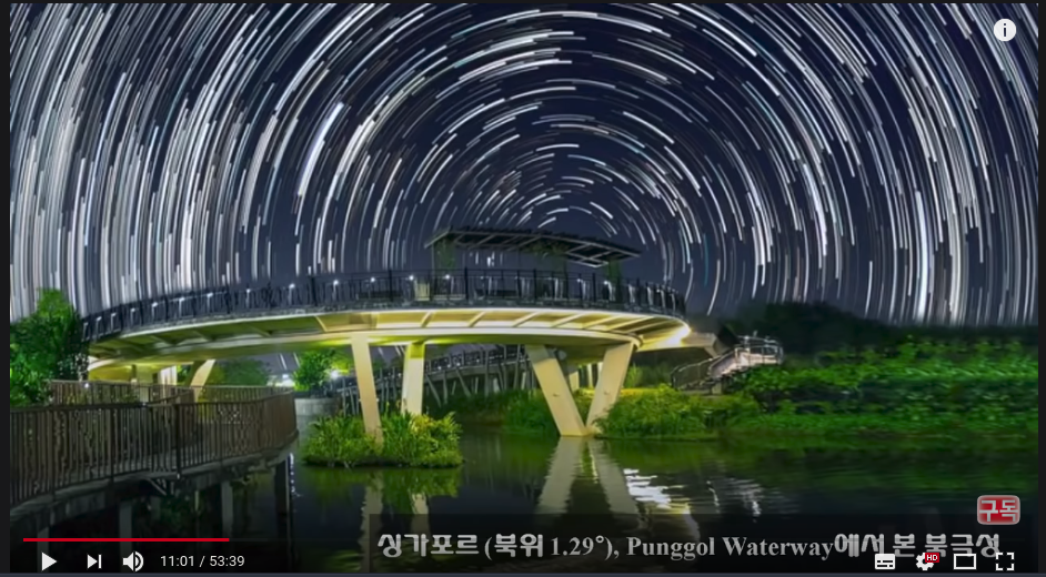
North star appearance (center) when you see it in Singapore
======================================================================
If you move to south beyond equator, you can't see north star
======================================================================
North star appearance (center) when you see it in Singapore
 ======================================================================
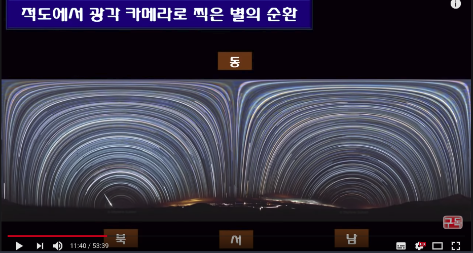
Rotating appearance of stars when you see stars in equator area
This is unique phenomenon which you only can see in equator area
======================================================================
Rotating appearance of stars when you see stars in equator area
This is unique phenomenon which you only can see in equator area
 ======================================================================
You can't see north star in sourthern area due to earth
======================================================================
You can't see north star in sourthern area due to earth
 ======================================================================
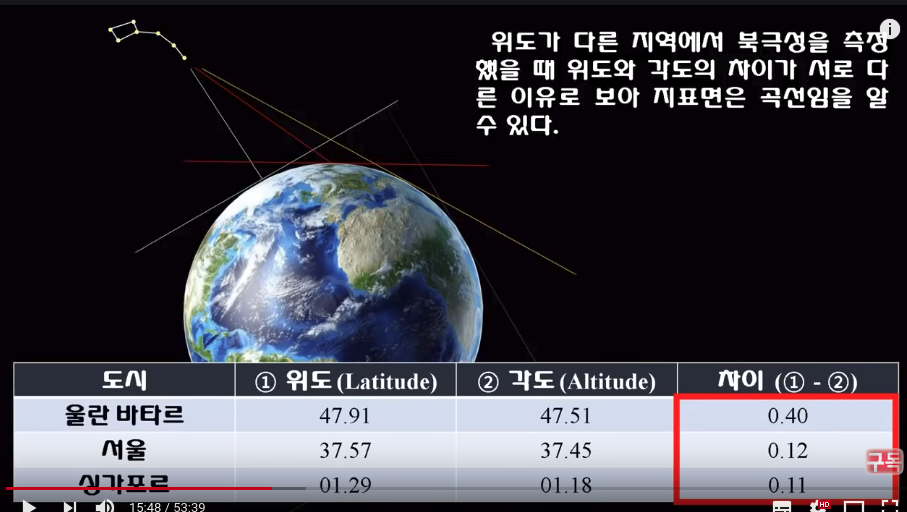
Differences (numbers in red box) become smaller as you go to southern areas.
Difference 0.40 is for Ulaanbaatar (far northern area)
Difference 0.12 is for Seoul (medium northern area)
Difference 0.11 is for Singapore (around equator area)
This means earth is sphere shape than flat shape.
======================================================================
Differences (numbers in red box) become smaller as you go to southern areas.
Difference 0.40 is for Ulaanbaatar (far northern area)
Difference 0.12 is for Seoul (medium northern area)
Difference 0.11 is for Singapore (around equator area)
This means earth is sphere shape than flat shape.
 ======================================================================
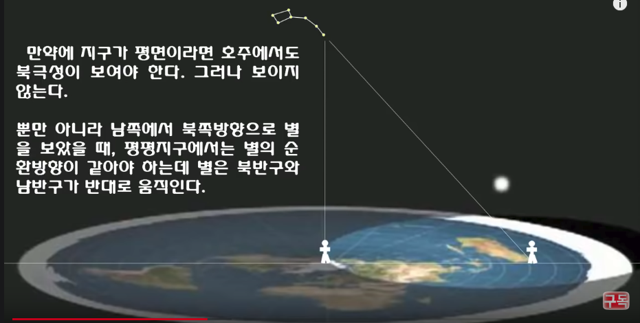
If earth is flat,
north star should be also shown in southern areas like Australia, Africa
======================================================================
If earth is flat,
north star should be also shown in southern areas like Australia, Africa
 ======================================================================
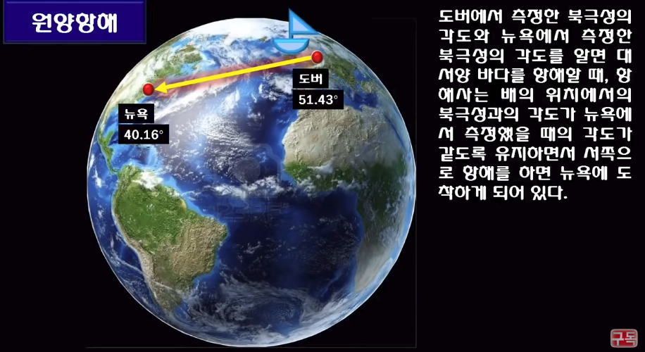
If you know angle between north star and Dover (town of England) and angle between north star and New York,
and if when you move through Atlantic ocean,
ancient sailing captain could arrive New York from Dover without modern GPU system
by moving ship with making angle between north star and ship same to angle betwen north star and New York,
(by using sailing navigation data which had been empirically obtained by old sailors and explorers)
and by moving ship towards western direction (by using compass)
======================================================================
If you know angle between north star and Dover (town of England) and angle between north star and New York,
and if when you move through Atlantic ocean,
ancient sailing captain could arrive New York from Dover without modern GPU system
by moving ship with making angle between north star and ship same to angle betwen north star and New York,
(by using sailing navigation data which had been empirically obtained by old sailors and explorers)
and by moving ship towards western direction (by using compass)
 ======================================================================
Civilization had been more thrived in northern areas.
It's because since older measure system depended on north star
so that they had almost no information which could help them to move to northern areas
So, before 15c, people almost couldn't go to far northern areas
======================================================================
People became knowing that there is south star below equator
After knowing existence of south star,
going around the entire world became possible by F. Magellan, Vasco da Gama, etc.
======================================================================
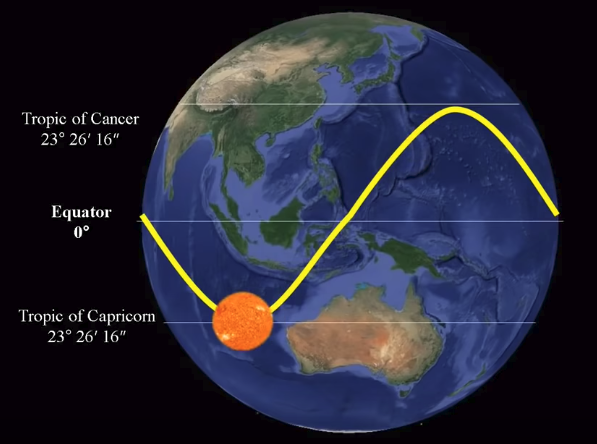
With criterion of northern areas,
there are tropic of cancer, equator, tropic of capricorn.
======================================================================
Civilization had been more thrived in northern areas.
It's because since older measure system depended on north star
so that they had almost no information which could help them to move to northern areas
So, before 15c, people almost couldn't go to far northern areas
======================================================================
People became knowing that there is south star below equator
After knowing existence of south star,
going around the entire world became possible by F. Magellan, Vasco da Gama, etc.
======================================================================
With criterion of northern areas,
there are tropic of cancer, equator, tropic of capricorn.
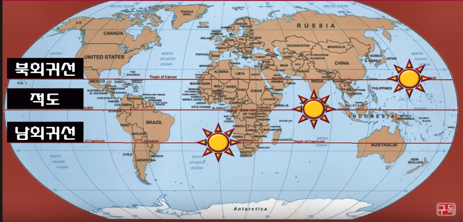 Tropic of cancer:
when summer, when sun is located in highest height,
angle between ground and sun is 90 degree
Equator:
When summer and fall, angle between ground and sun is 90 degree.
Tropic of capricorn:
When winter, angle between ground and sun is 90 degree.
If you have criterion of southern areas,
above pattern becomes opposite.
When you measure location of sun rise everyday for 1 year
locations become slightly differ every day.
After 1 year, location of sun rise becomes first day location.
If you draw dots based on above differences for 1 year,
you get this line
Tropic of cancer:
when summer, when sun is located in highest height,
angle between ground and sun is 90 degree
Equator:
When summer and fall, angle between ground and sun is 90 degree.
Tropic of capricorn:
When winter, angle between ground and sun is 90 degree.
If you have criterion of southern areas,
above pattern becomes opposite.
When you measure location of sun rise everyday for 1 year
locations become slightly differ every day.
After 1 year, location of sun rise becomes first day location.
If you draw dots based on above differences for 1 year,
you get this line
 ======================================================================
Mercator map has distortions in far northern and far southern areas
but has precision around equator areas.
Even if there are distortions in mercator map, why do people use that map?
It's because that map is useful
when you move from east area to west area and from west area to east area
You shouldn't use mercator map when you move from north area to south area or south area to north area
In that situation,
you should use transverse mercator map when you move from ONLY north area to south area via "Atlantic ocean"
(not through Pacific ocean, not southern area to northern area)
======================================================================
Mercator map has distortions in far northern and far southern areas
but has precision around equator areas.
Even if there are distortions in mercator map, why do people use that map?
It's because that map is useful
when you move from east area to west area and from west area to east area
You shouldn't use mercator map when you move from north area to south area or south area to north area
In that situation,
you should use transverse mercator map when you move from ONLY north area to south area via "Atlantic ocean"
(not through Pacific ocean, not southern area to northern area)
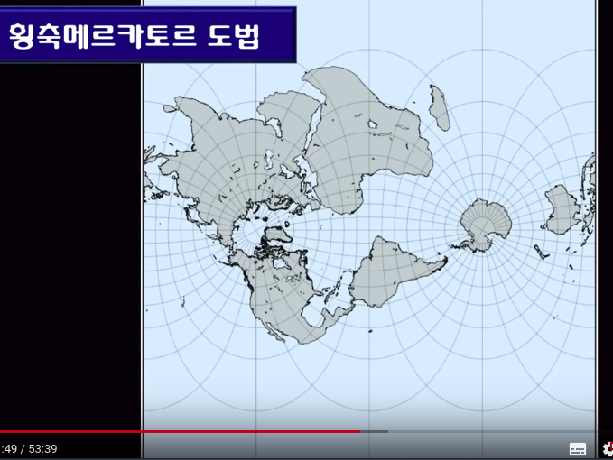 In Mediterranean ocean, azimuthal equidistant map is precise so that it's much used in that area
 ======================================================================
Why does UN use following map in its flag?
======================================================================
Why does UN use following map in its flag?
 Each map (mercator, transverse mercator, azimuthal equidistant, etc) has subjective purposes
For example, people see world with criterion of their own location
Azimuthal equidistant map is for countries around mediterranean ocean.
Transverse mercator map is for countries around northern American and Europe
If UN uses transverse mercator, people of Asia, Africa can get uncomfortable.
If UN uses mercator map, people of Canada, Russia (both far northern), Austrailia (far southern) can get uncomfortable.
So, UN draws map in terms of north pole area
Then, why not south pole area?
If you see world from south pole, you hardly see continents but see more oceans.
So, criterion of south pole is chosen.
That is, world map in UN flag is neutral map in terms of polical view
Each map (mercator, transverse mercator, azimuthal equidistant, etc) has subjective purposes
For example, people see world with criterion of their own location
Azimuthal equidistant map is for countries around mediterranean ocean.
Transverse mercator map is for countries around northern American and Europe
If UN uses transverse mercator, people of Asia, Africa can get uncomfortable.
If UN uses mercator map, people of Canada, Russia (both far northern), Austrailia (far southern) can get uncomfortable.
So, UN draws map in terms of north pole area
Then, why not south pole area?
If you see world from south pole, you hardly see continents but see more oceans.
So, criterion of south pole is chosen.
That is, world map in UN flag is neutral map in terms of polical view